
The City of Worcester plays an active role in floodplain management, working to minimize flood hazards, educate residents, and ensure compliance with applicable regulations.
Know Your Flood Hazard
Did you know that the City of Worcester makes available (for free!) information which may be of use in determining a property's susceptibility to flooding? Upon request, the City will provide information such as:
- Whether or not a property is located within a Special Flood Hazard Area (SFHA) as shown on the current Flood Insurance Rate Map (FIRM) for the City.
- Whether or not a property is located within a regulatory floodway, a repetitive loss area, or other areas that have historically experience flooding but are not located within an area mapped as a SFHA on the FIRM.
- Additional flood map information for sites in the SFHA, such as FIRM panel number, flood zone, base flood elevation or depth (if shown on the FIRM or detailed in a Flood Insurance Study), as well as the source of flooding.
To request information, please contact the Division of Planning & Regulatory Services at planning@worcesterma.gov or 508-799-1400 ext. 31440. Please include the street address of the property in question at the time of your inquiry.
Flood Insurance
Most homeowners insurance doesn't cover flood damage, so flood insurance is critical to protect against the financial loss that can result from a flood. Flood insurance is required for properties in the SFHA financed by federally backed mortgages, but it is also important for properties outside of mapped flood hazard areas, as nearly one-third of NFIP insurance claims come from outside the SFHA.
As a participating community, Worcester property owners and residents can obtain flood insurance through the National Flood Insurance Program (NFIP). The City also participates in the Community Rating System (CRS) program, committing to floodplain management practices that exceed the minimum NFIP requirements, which results in a discount of up to 15% on flood insurance premium rates.
To purchase flood insurance, contact your insurance agent or visit Floodsmart.gov for more information.
Build Responsibly
Always check with the Department of Inspectional Services and the Division of Planning & Regulatory Services before you build on, alter, regrade or fill your property. Permits are required for development in the floodplain, and there are specific requirements in Massachusetts State Building Code and the Massachusetts Wetlands Protection Act that aim to mitigate the risk of flood damage as well as injury or loss of life.
Flood Preparedness
There are many things that can be done to prepare for the next potential flood. View the list below for suggestions about how to be prepared if a flood threatens your area.
- Talk to your insurance agent about your coverage
- Prepare a list of emergency telephone numbers
- Assemble cleanup and recovery supplies
- Make a record of all of your personal property
- Store photocopies of important documents at a location away from your house
- Prepare a flood response plan
- Identify two places where family members can meet if you are split up
- Shut off the gas and electricity and move valuable contents upstairs
Learn more by visiting Ready.gov.
Flood Safety & Tips
If you own property in the City of Worcester and are subject to flooding, the following information and suggested activities are important to you. Additional information can be found on the FloodSmart website.
View the tips below to learn how to be safe during a flood.
- Do not walk through flowing water
- Do not drive through a flooded area
- Stay away from power lines and electrical wires
- Have your electricity turned off by the Power Company
- Look out for small wild animals
- Look before you step
- Be alert for gas leaks
- Carbon monoxide exhaust kills
- Clean everything that got wet
Protect Natural Floodplain Functions
Streams, wetlands, channels and catch basins are essential to preventing a flood. Do not dump or throw anything into streams, channels or catch basins that drain or carry stormwater. Dumping any material in a waterway or catch basin is illegal and may be a violation of the City of Worcester's Wetlands Protection Ordinance. Any alteration of areas within 100' feet of a stream or wetland may require permitting with the Worcester Conservation Commission.
FEMA Resources
There are many helpful resources available for free from FEMA to help understand and prevent losses to property. Click on the dropdown menu below to view a list of some of these resources.
- Above the Flood: Elevating Your Floodprone House
- Answers to Questions About the National Flood Insurance Program
- Coastal Construction Manual
- Elevated Residential Structures
- Mitigation of Flood and Erosion Damage to Residential Buildings in Coastal Areas
- Protecting Building Utilities from Flood Damage
- Protecting Floodplain Resources
- Protecting Manufactured Homes from Floods & Other Hazards
- Reducing Damage from Localized Flooding
Elevation Certificates
Elevation Certificates (ECs) are documents that provide elevation information for individual structures to ensure compliance with local, state, and federal floodplain management requirements. As part of its participation in the CRS Program, the City of Worcester maintains and makes available all ECs for construction of new structures or substantial improvement of existing structures in the floodplain. Below is a list of ECs maintained by the City:
- Elevation Certificate - 331 Bridle Path
- Elevation Certificate - 21 Ellsworth Street
- Elevation Certificate - 29 Endicott Street
- Elevation Certificate - 248 Mill Street
- Elevation Certificate - 14 New Bond Street
- Elevation Certificate - 575 Park Avenue
- Elevation Certificate - 633 Park Avenue
- Elevation Certificate - 642 Park Avenue
- Elevation Certificate - 75 Quinsigamond Avenue
- Elevation Certificate - 510-512 Southbridge Street
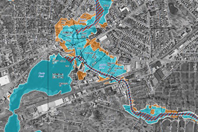
FEMA Flood Map Update
FEMA released preliminary maps as part of the Blackstone River Watershed Risk Map Update. The new maps mark the first significant update to the city's flood maps since 2011.
Contact Information
Address
Planning & Regulatory Services
City Hall Room 404
455 Main Street
Worcester, MA 01608
Contact
Phone: 508-799-1400
Fax: 508-799-1406
planning@worcesterma.gov
![]()
Hours
Monday - Friday
8:30 a.m. - 5 p.m.