About the FEMA Map Update
The Federal Emergency Management Agency (FEMA) is responsible for mapping the nation's flood risk. Special Flood Hazard Areas (SFHAs), also known as the 100-year or 1% annual chance floodplains, are depicted on FEMA's Flood Insurance Rate Maps (FIRMs). SFHAs are areas where floodplain management regulations are enforced and where the mandatory purchase of flood insurance applies.
On November 26, 2024, FEMA released preliminary maps as part of the Blackstone River Watershed Risk Map Update. This watershed covers almost the entire City of Worcester, and the new maps mark the first significant update to the city's flood maps since 2011.
FEMA conducted a comprehensive re-study of the Middle and Blackstone Rivers, as well as a re-study of approximate flood zones across the city. While other flooding sources were not re-studied, the mapped extents of the SFHAs were updated using improved topographic LIDAR data.
The preliminary maps for the Blackstone River Watershed are expected to become effective in the summer of 2028, at which point they would be used for purposes of the mandatory purchase requirement or building code requirements for construction in the floodplain.
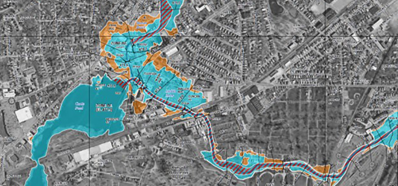
Compare the New Preliminary Maps to the Effective Maps
Compare the existing effective FEMA flood maps to the proposed draft or preliminary maps using the slider button at the center of the map. Drag the slider button to the right to reveal the existing FEMA flood map information. Move it to the left to see the preliminary information. The preliminary flood zones are symbolized with a pattern of white-outlined squares. Click on the legend button on the right side of the viewer for additional details about what the map displays.
On the map the Special Flood Hazard Area (SFHA), known as the 100-year or regulatory floodplain, is shown in blue. The 500-year floodplain is show in orange. Floodways (areas where water moves fast) are shown in red/blue stripes.
Existing "effective" flood maps are shown on the left of the slide bar, while the new, proposed draft or "preliminary" maps are shown on the right.
Mandatory Purchase Requirement
The Special Flood Hazard Area (SFHA) is also known as the 100-year regulatory floodplain or 1% annual-chance floodplain. FEMA represents this area using different flood zones that begin with A (A, AE, AH, AO) or V. This area is depicted in the above viewer by the blue polygons.
Under the provisions of the Flood Disaster Protection Act of 1973, individuals, businesses and others buying, building or improving property located in an SFHA are required to purchase flood insurance as a prerequisite for receiving any type of direct or indirect federal financial assistance (e.g., any loan, grant, guaranty, insurance, payment, subsidy or disaster assistance) when the building or personal property is the subject of or security for such assistance. (FEMA)
This means that flood insurance is mandatory for you if your structure is located in the SHFA and you have a federally backed mortgage (note: most mortgages are federally backed). Generally, a traditional homeowners' insurance policy does not provide coverage for flooding.
Visit our Floodplain Management page to access resources to help you to prepare for a flood and protect your property from flooding and to learn more about the City's floodplain management practices.
Informational Public Meetings
The City of Worcester held two informational public meetings about FEMA's map updates in the Spring of 2025. One was hosted in-person at the Worcester Senior Center and the other was held virtually via Zoom. Below are the recordings of these meetings in English and Spanish, as well as the presentation slides.
- FEMA Flood Map Updates - Session Two - 04/23/2025 - Virtual Presentation
- FEMA Flood Map Updates - Session Two - 04/23/2025 - Virtual Presentation (Español)
- FEMA Flood Map Updates Presentation
Additional Information
For more information about the flood map update or for any general questions on floodplain management, please contact the Division of Planning & Regulatory Services at planning@worcesterma.gov or 508-799-1400 ext. 31440.
Contact Information
Address
Planning & Regulatory Services
City Hall Room 404
455 Main Street
Worcester, MA 01608
Contact
Phone: 508-799-1400
Fax: 508-799-1406
planning@worcesterma.gov
![]()
Hours
Monday - Friday
8:30 a.m. - 5 p.m.